Many projects fail not because of a lack of minerals, but due to poor initial decisions. This service solves:
Blind Exploration
We identify critical targets of interest before the first field team even sets foot on the ground.
Unnecessary Costs
Drastic reduction of logistical expenses in areas with zero or low mineralization potential.
Operational Risk
We increase safety and operational efficiency through high-resolution preventive remote analysis.
The Technical Foundation of
Smart Exploration
Before investing time, money, and effort in the field, we perform a comprehensive desktop analysis to identify, prioritize, and rank zones with the highest probability of mineral concentration, reducing uncertainty and maximizing return on investment from the start.
Mapa de Tesoros does not sell “generic maps”; it delivers technical criteria, strategic vision, and a competitive advantage to decide exactly where to explore—and where not to.
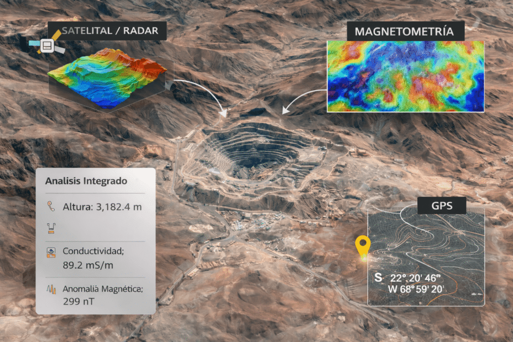
We apply an advanced integration of geospatial analysis technologies, tailored to the geological context of the study area.
Optical-Spectral
We perform Optical-Spectral Analysis to identify alterations and associated mineral signatures.
SAR Radar
We utilize satellite radar (SAR) for structural analysis, drainage, lineaments, and geological control.
Magnetometry
(Referential, where the geological context allows) to support structural and lithological interpretation.
Cartography
Analysis of official and technical geological and mining cartography.
Background Review
Review of historical mineral occurrences and mining activity records.
Geographic Information Systems
Full integration into Geographic Information Systems (GIS).
The entire process is geared toward detecting consistent patterns, not isolated anomalies.
What do we deliver?
The client receives clear, actionable, and decision-ready products:
01 – Hierarchical mineral potential maps
02 – Identification of priority zones and areas
03 – Interpreted technical analysis (not just images)
04 – Cartographic inputs for field planning
05 – Solid technical foundation for investment, concession, or targeted exploration
What does the client gain?
This service is designed to generate real value, not just information:
Earn Money
By investing where the highest technical probability exists.
Save Time
By avoiding unnecessary exploration.
Reduce Risks
Economic, environmental, and social risks.
Gain Status
By working with professional methodology, technology, and criteria.
Exploring with this analysis is exploring with an advantage.
Who is this service for?
Designed specifically for:
Mining Rights Holders
Exploration Investors
Small and Medium-sized Operators
Companies looking to make informed decisions
National and International Projects
Especially recommended for those who understand that the best mining decision is made before setting foot in the field.
IMPORTANT!
This service is scalable and expandable. Based on the results, the client can request additional phases such as field validation, technical signaling, or strategic exploration management.