Dirección Pje. Raúl Jiménez Chavez 16B-9, Puerto Maldonado
Horario de atención Lunes a Sábado: 8AM - 6PM
GEOSPACIAL INTELLIGENCE FOR MINING EXPLORATION
Before investing in that land, discover its true mining potential
In minutes, get a clear and professional preliminary assessment that interprets the geological, territorial, and mining context of the area to help you identify opportunities before investing time, machinery, or money, and make decisions with greater confidence.
Answer: Where should I begin to reduce risk? Integrate multiple sources to define priority exploration areas
3
Execute with greater confidence
FIELDWORK
Validate priority areas in the field and make decisions with greater accuracy and less uncertainty
WHY START WITH A PRELIMINARY REPORT?
Most exploration errors begin before setting foot on the terrain.
Every mining project begins with a decision.
The problem is that this decision is often made with incomplete information, third-party recommendations, or simply based on expectations.
Our Preliminary Mining Potential Report allows you to understand the mineral context of a site before investing time, machinery, or capital, reducing uncertainty and increasing the confidence in your decisions.
Understand the potential of the land
Gain a clear understanding of the geological and mineral context before investing resources in the field.
Reduce uncertainty
Make decisions based on reliable technical information, not assumptions or intuitions.
Save time and resources
Avoid weeks or months of preliminary work without direction or clear objectives.
Move forward with confidence
When you decide to explore, you’ll know where to start and how to prioritize your efforts.
It doesn't replace a detailed scan, it makes it much smarter
Results in minutes
Professional methodology
Available 24/7
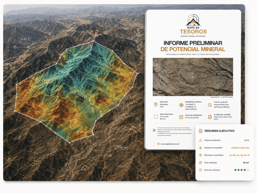
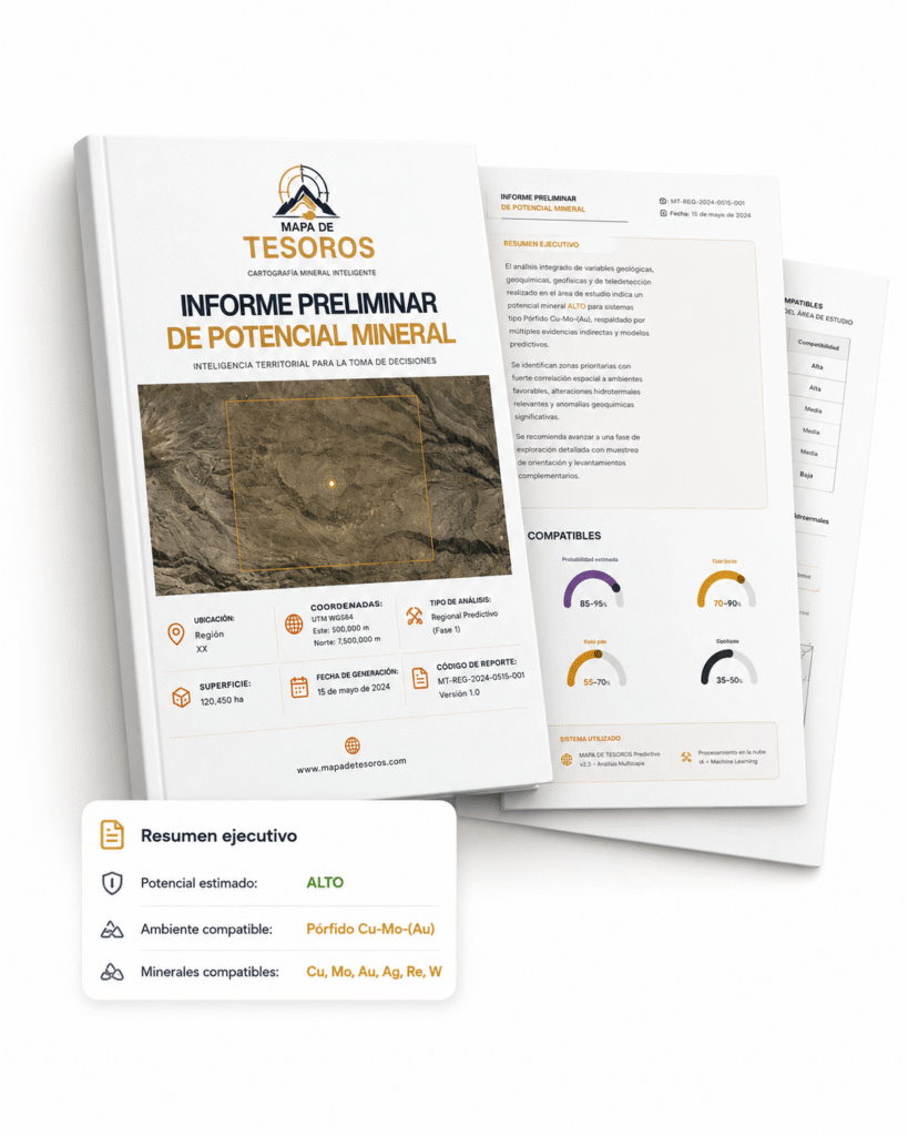
WHAT YOU WILL RECEIVE
What does your Preliminary Report include?
You won’t just receive a map. You’ll receive a clear, structured, and professional assessment of the mining context of your land to help you decide if it’s worth moving forward.
Executive Summary
Quick overview of the area's potential and the type of environment interpreted
Ranking of compatible minerals
Relative compatibility of minerals according to the analyzed context.
Territorial and geological context
Location, relief, geology, and terrain characteristics.
Regional metallogenic and mining context
Relevant mineralizing patterns and background information.
Integrated MTD Interpretation
Automatic synthesis of territorial, geological, and mining evidence.
Exploratory opportunities identified
Criteria and areas of interest for further evaluation.
Limitations and Scope
What this preliminary report can and cannot conclude.
It doesn't tell you where to drill. It helps you decide if it's worth proceeding.
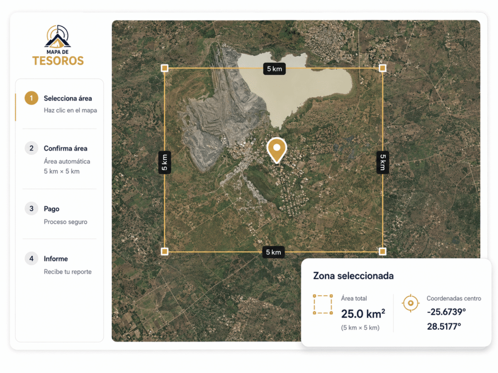
SIMPLE AND CLEAR PROCESS
How does it work?
Get your Preliminary Report in just a few steps, from selecting the land to delivering your professional report.
Guided process
Secure Payment
Professional PDF Report
Select your land
Quick reading of the area's potential and the type of environment interpreted
Confirm the area
Relative compatibility of minerals according to the analyzed context.
Make the payment
Location, topography, geology, and terrain characteristics.
Receive your report
Mineralizing models and relevant environmental background.